


AirMagnet Survey Professional v5.0 Build 10866

AirMagnet Survey Professional v5.0 | ~ 172.6 MB
SUNNYVALE, Calif., October 4, 2007 - AirMagnet Inc., the leader in wireless network assurance, released AirMagnet Survey v5.0.
The new Survey 5.0 release offers other key enhancements, including an integration with Google Earth to enhance outdoor Wi-Fi site surveys. Users can overlay Survey results onto Google Earth maps to pinpoint areas of interference and noise, while taking advantage of Google Earth's GPS accuracy and flexibility to zoom in to any level of detail. This makes AirMagnet Survey uniquely suited for city-wide Wi-Fi networks-like in Mountain View, Calif., where Google is creating a municipal wireless network covering the entire city and delivering free Internet access to residents and visitors-which increasingly require scientific outdoor site planning and surveying.

AirMagnet Survey Professional v5.0 Build 10866
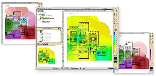
Additional new features of AirMagnet Survey v5.0 include:
- Microsoft Windows Vista Support.
- Ability to Locate Stations using Survey Data.
- Improved Device Icons and Names.
- Survey Data File Comparison.
- 802.11i (AES) Support.
- Microsoft Visio Format Support.
- Microsoft Virtual Earth Integration.
- Speed Data for Passive/Virtual Surveys.
- Network Card Simulation.
- Virtual AP Grouping.
- Configuration Profiles.
- Spectrum Heat Map Display.
- Spectrum Interference Alarms and Analysis take Survey's integration with Spectrum Analyzer a step further by providing alarms when spectral interfe-rence is detected and identifying specific sources of interference, enabling surveyors to account for interference at the planning stage, before it affects network performance.
- Roaming Control makes AirMagnet's unique method of active surveying even more active, by allowing the user to set a standard roam rate during a site survey to more accurately recreate the true end-user experience, rather than base planning on the signal strength, connection speed and number of packet retries experienced by a single wireless machine.
- Integration with AirMagnet Laptop Analyzer enables site surveys conducted using Laptop Analyzer's survey tool to be imported into Survey. Field agents armed with Laptop Analyzer can use it to conduct live surveys and send them back to Survey at a central location for further analysis.
Additional new features of AirMagnet Planner include:
- Access Point Overlap shows on the map display where APs on the same channel overlap above a user-defined threshold. Users can also investigate an AP in detail to plot the total combined interference to a particular access point from all other APs.
- Advanced Network Simulation provides full control of the proposed wireless infrastructure. Users can add APs to any location and experiment to find the ideal AP placement for the environment with independent settings for both 802.11a and 802.11b/g radios. Users can predict performance based on changes to the AP channel, IP address, transmit power, antenna type, orientation and height.
- Predicted Wi-Fi Environment Report and Bill of Materials can be auto-matically generated upon completion of the site survey. The report outlines the predicted Wi-Fi landscape, including areas of dead spots and interference, how many APs to deploy and how to configure APs for optimal coverage and performance.
RAPIDSHARE download link
AirMagnet Survey Professional v5.0 Build 10866 part1 (95.8 MB)
AirMagnet Survey Professional v5.0 Build 10866 part2 (67.3 MB)
pass: www.AvaxHome.ru
AirMagnet Survey Professional v5.0 Build 10866 part1 (95.8 MB)
AirMagnet Survey Professional v5.0 Build 10866 part2 (67.3 MB)
pass: www.AvaxHome.ru
(downloaders please use original download link)
Please don't put any RAPIDSHARE.COM mirrors !!!