

Able Software RV2 v7.0.20120720

Able Software RV2 v7.0.20120720 | 8 Mb
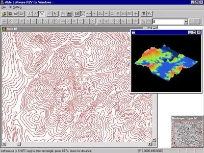
Able Software R2V for Windows, is a powerful raster to vector conversion software at a reasonable price. R2V combines the power of intelligent automatic vectorizing technology with an easy-to-use, menu-driven, graphical user interface in the Microsoft Windows environment. The software converts scanned maps or images to vector formats for mapping, geographic information systems (GIS), CAD, and scientific computing applications. The system is easy to use and can be learned quickly by users with any level of technical background.
R2V provides an easy and complete solution to digitize vector data from image sources, such as scanned maps and drawings, aerial photos, and satellite imagery.
For many images, the entire raster to vector conversion process is fully automatic and needs no human intervention. You display the scanned image on screen and you select the vectorization command. That is all it takes! All the lines are extracted in seconds and displayed right on top of the image for you to verify and edit. Powerful editing and processing functions are provided to edit, geo-reference, and label your data. R2V has all the tools to get a perfect set of vector data faster and easier than any other methods.
With R2V, you can forget about slow and inaccurate hand tracing on a digitizing tablet, simply scan your map or drawing and let R2V vectorize it automatically, at a high accuracy level. A typical contour or parcel map scanned at 200 DPI (dots/inch) as black and white or grayscale can be vectorized in seconds or minutes on a Pentium PC.
Home Page - http://www.ablesw.com/r2v/r2v.html